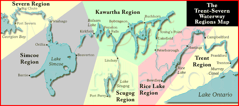
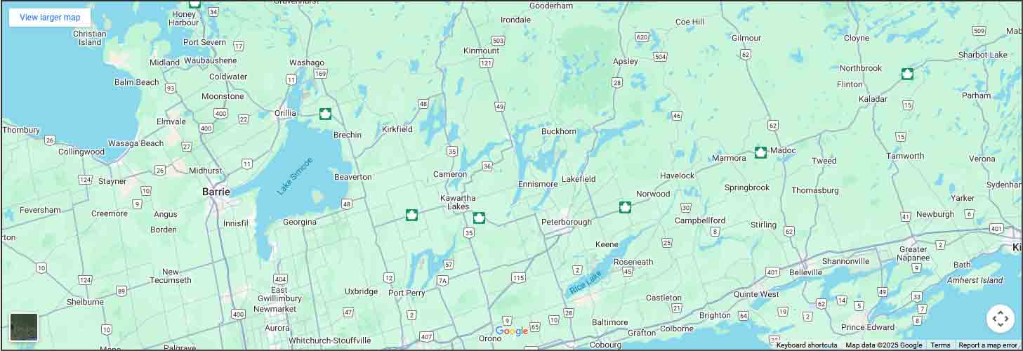
The Trent Severn Waterway, Trent Canal


The Trent Severn Waterway, Trent Canal web site offers maps, lock locations, GPS coordinates, distance from lock to lock chart, hours of operation, history of The Trent Severn Waterway, links to Parks Canada who are responsible for The Waterway. Trent Severn Maps include a printable map you can take with you plus quick map links for 35 Towns with streets, grocery store and LCBO and beer store locations all sized to fit your phone or tablet. Trent Severn connects Trenton on Lake Ontario to Port Severn on Georgian Bay. A distance of 387 km (240 miles) and a rise of 180 meters (590 feet) above Lake Ontario and 80 meters (260 feet) above Georgian Bay at the Trent systems highest point, Balsam Lake. The lifting and dropping process incorporate 41 locks, a marine railway and two hydraulic lift locks including the worlds highest, 65 foot lift (20 meters), located at Peterborough Ontario. The system was started in 1833 and completed in 1920. We have added quick links to 10 translated languages.

Rent Houseboats on Ontario's Trent Severn Waterway
The Batflip is a blog about the Toronto Blue Jays disguised as a newsletter.
design, dns management, seo, consulting & more
Over Population has created Global Warming which in turn has created Climate Change
View some of our responsive internet web designs with the latest html and CSS.

Trent Severn: Lock/Station/GPS

Lock# and Name
GPS - Links to
Google Maps
1, Trenton 44.122102,-77.5945094
2, Sidney 44.1299248,-77.593872
3, Glen Miller 44.1550178,-77.5873082
4, Batawa 44.1681178,-77.5884711
5, Trent 44.1852363,-77.593925
6, Frankford 44.1978221,-77.5935244
7, Glen Ross 44.2661165,-77.5984492
8, Percy Reach 44.2362137,-77.7864701
9, Meyers 44.247155,-77.8023595
10, Hauges Reach 44.2674334,-77.7958095
11/12, Ranney Falls 44.2915204,-77.8155936
13, Campbellford 44.3196533,-77.7886936
14, Crowe Bay 44.2331236,-77.7523884
15, Healy Falls 44.370739,-77.7805857
16/17, Healy Falls 44.3728352,-77.7817333
18, Hastings 44.3083532,-77.9588177
19, Scott's Mill 44.2886853,-78.3107699
20, Ashburnham 44.2995225,-78.3066252
21, Peterborough 44.3076708,-78.3027591
22, Nassau Mills 44.3653615,-78.2926905
23, Otonabee 44.3724787,-78.2896806
24, Douro 44.3886236,-78.2716549
25, Sawer Creek 44.4006726,-78.2650433
26, Lakefield 44.4191165,-78.271359
27, Young's Point 44.4881567,-78.2349991
28, Burleigh Falls 44.5599164,-78.2100727
30, Lovesick 44.5529251,-78.2418823
31, Buckhorn 44.555173,-78.3493427
32, Bobcageon 44.5375815,-78.5479718
33, Lindsay
44.3573749,-78.7374048
34, Fenelon Falls 44.5360586,-78.7395755
35, Rosedale 44.5717862,-78.7802627
36, Kirkfield 44.5896663,-78.9921701
37, Bolsover 44.5099486,-79.1085168
38, Talbot 44.5099486,-79.1085168
39, Portage 44.498728,-79.1334042
40, Thorah 44.4939798,-79.1403957
41, Gamebridge 44.4866986,-79.151467
42, Couchiching 44.7698083,-79.3502941
43, Swift Rapids 44.5718121,-78.7825531
44, Big Chute 44.5718121,-78.7825531
45, Port Severn 44.5718121,-78.7825531
Return to Top

Trent Severn: Region/Distance/Chart

Lock, Region
Lake Ontario
KM - Miles
Chart
1, Trent
0 - 0
2021
2, Trent
3.9 - 2.4
2021
3, Trent
6.2 - 3.9
2021
4, Trent
8.3 - 5.2
2021
5, Trent
10.3 - 6.4
2021
6, Trent
11.7 - 7.3
2021
7, Trent
22.2 - 13.8
2021
8, Trent
40.7 - 25.3
2021
9, Trent
42.5 - 26.4
2021
10, Trent
45.0 - 28.0
2021
11/12, Trent
47.8 - 29.7
2021
13, Trent /
51.8 - 32.2
2021
14, Rice Lake
54.2 - 33.7
2021
15, Rice Lake
58.2 - 36.2
2021
16/17, Rice Lake
58.8 - 36.5
2021
18, Rice Lake
82.3 - 51.1
2022
19, Rice Lake /
142.8 - 88.7
2022
20, Kawartha
144.5 - 89.5
2023
21, Kawartha
145.0 - 90.1
2023
22, Kawartha
151.7 - 94.3
2023
23, Kawartha
152.6 - 94.8
2023
24, Kawartha
155.1 - 96.4
2023
25, Kawartha
156.6 - 97.3
2023
26, Kawartha
158.9 - 98.7
2023
27, Kawartha
168.1 - 104.5
2023
28, Kawartha
181.8 - 113.0
2023
30, Kawartha
182.7 - 114.8
2023
31, Kawartha
194.2 - 120.7
2023
32, Kawartha /
222.4 - 138.2
2025
33, Sucog /
251.6 - 156.3
2026
34, Kawartha
247.2 - 153.6
2025
35, Kawartha
252.9 - 157.2
2025
36, Kawartha /
272.6 - 169.4
2025
37, Simcoe
284.9 - 177.0
2025
38, Simcoe
286.5 - 178.1
2025
39, Simcoe
289.1 - 179.6
2025
40, Simcoe
289.8 - 180.1
2025
41, Simcoe
290.9 - 180.7
2025
42, Simcoe /
337.8 - 209.9
2028
43, Severn
361.2 - 224.5
2029
44, Severn
374.1 - 232.5
2029
45, Severn
387.1 - 240.6
2029
Return to Top

Aged Domains, make an offer

CentralOntario.com, CanadianExposure.com, OLR.ca, CottageCountryOntario.com, OntarioCottages.com, PTBOregion.com, TheTrentSevernWaterway.com, OntarioTimes.com, TrentCanal.com, TrentCottages.com, 2ES.net, TrentWaterway.com, ShopKawartha.com, KawarthaDirectory.com, Serving.com, ATQ.biz, TheCorrespondent.ca, PublishedHere.com, WritersORG.com, WritersPlayPen.com


Rent, Buy or list cottages in Ontario by owners.

2023 Trent Severn: Operating Hours


-
-

May 19 to June 18, 2023
Monday to Thursday 10:00am – 3:30pm
Friday to Sunday; and Victoria Day (May 22) 9:00am – 6:30pm


-
-

Jun 19 to Sept 4, 2023
Monday to Thursday 9:00am – 5:30pm
Friday to Sunday; and Canada Day (July 1), Civic Holiday (Aug. 7), Labour Day (Sept. 4) 9:00am – 6:30pm


-
-

Sept 5 to Oct 9, 2023
Monday to Friday 10:00am – 3:30pm
Saturday - Sunday; and Thanksgiving (Oct. 9) 9:00am – 4:30pm

Links to Parks Canada:
Tel: 705-750-4900 or Tel: 1-888-773-8888 or Email: information@pc.gc.ca

NOTE:
Lockstations are unstaffed after hours. Authorized visitors are asked to exercise caution. Unpermitted access to lockstations is prohibited between 10pm and 6am. For emergencies after hours, please call 911 for police, fire, ambulance. To report illegal harvesting of fish or wildlife, please call the Ministry of Natural Resources and Forestry TIPS line at 1-877-TIPS-MNR (847-7667).

LAST LOCKAGE - IMPORTANT
Follow these guidelines to maximize chances of being locked through at the end of the day:
All vessels must arrive at the designated blue zone at least 30 minutes before closing time.
At swing bridges, the last bridge swing will be 20 minutes prior to closing time.
NOTE: Station opening and last lockage times are not guaranteed and may be affected by water management duties, maintenance activities or other types of navigation interruptions.

Nautical Charts
Nautical charts can be purchased during the navigation season at Locks 1, 18, 36, 42 and 45, or at the Peterborough Lift Lock Visitor Centre Gift Shop.

Maximum Overnight Mooring Periods
5 Nights - Locks 1 to 18
2 Nights - All other locks, Murray Canal swing bridges and bridge #50.
Lock 6 offers electrical hook ups and showers (nearby); Lock 34 offers electrical and water hook ups.
Note: Overnight Mooring passes include one free camp site.

The Trent Severn Waterway

The six regions of The Trent-Severn WaterwayBrief History of The Trent-Severn Waterway
The start to finish time line spans eighty-seven years with the systems construction starting in 1833 at Bobcaygeon and finishing in 1920 at Port Severn, three hundred and eighty-seven kilometers from Lake Ontario.
The Navigation channel runs a depth of six feet from start to finish. The locks vary in raising the water level some exceptions are; flight locks, the Big Chute Marine Railway with a lift of eighteen meters (58 feet), the Kirkfield Lift Lock with an average lift of fifteen meters (49 feet) )and the Peterborough Lift Lock (finished in 1904) with a lift of twenty meters (65 feet).
Peaking at Balsam Lake at 180 meters (600 feet) above Lake Ontario and 80 meters (250 feet) above Lake Huron’s, Georgian Bay.
Standard lock dimensions are one hundred and twenty feet long by thirty-two feet wide. The two exceptions are the lock 44, the Big Chute Marine Railway at one hundred feet long by twenty-four feet wide and lock 45 at Port Severn is only eight-four feet long and twenty-three feet wide setting the limit if you wish to traverse The Trent Severn Waterway from one end to the other.
Two major upgrades were at Big Chute in 1960 and combining two locks at Burleigh Falls in 1968 eliminating lock 29.
• The Trent Severn Waterway is Central Ontario's 387 kilometers of waterway utilizing 41 locks, a marine railway and 2 hydraulic lift locks. The highest point, Balsam Lake is 180 meters (590 feet) above Lake Ontario and 80 meters (260 feet) above Georgian Bay.
• Navigation here is easy, all the key data is on one page. A click to the printable map or business directory or towns you pass by with quick links to their street map, grocery shopping, LCBO and region.
• Enjoy relaxing, activities or the sights of Central Ontario including the Peterborough Lift Lock or the Big Chute Marine Railway.
• We use 387 km instead of 386 km because that is what we get things to add up to.
• Balsam Lake is the highest point in the system, not Rosedale or Kirkfield. Kirkfield is 14.9 m below Balsam and Rosedale 1.2 m below.
• The Kirkfield Lift Lock Chambers rise to one foot below Balsam Lake, the system works when Balsam fills this area in the chamber increasing the weight, allowing it to descend so the opposite chamber to can rise. The chamber coming down must always have more water (weight) for the design to function.
• There is no lock 29 as two locks were replaced by one at Burleigh Falls.
• Purdey's Mills aka Lindsay aka City of Kawartha Lakes, is a side branch of The Trent-Severn Waterway accessing Lake Scugog.

Trent-Severn Waterway over the years has been called simply trent severn or severn travel or trent severn canal or trent severn water or trent waterway or severn canal or trent canal and all names aptly describe The Trent Severn Waterway. Here at our site, TheTrentSevernWaterway.com, we source the single details that you will need to use this resource running through Central Ontario, Canada.

We employ and are in the midst of employing some of the following web sites to help those seeking The Trent Severn Waterway to do so. These websites are: thetrentsevernwaterway.com, trentcanal.com, trentcottages.com, trenthouseboatrentals.com, trentwaterway.com, severnwaterway.com and ontariowaterway.com . Hopefully this displays our committment to this great resource and helps you along the many pathways, onshore and offshore, of The Trent Severn Waterway! With thousands of features the must see parts are the Peterborough Hydraulic Lift lock, the world's highest hydraulic lift lock, the Kirkfield Lift Lock and the Big Chute Marine Railway, a portage taking you and your craft from The Trent Severn Waterway over to Georgian Bay, part of Lake Huron.

Trent Severn printable map, click here or jump to: Lock/Station/GPS & Links or Lock/Region/Distance/Chart or Return to Top

Some Sample Website Designs by Kawartha

Fright Free Children and the effects of low-level violence
Hobies Sports store in Peterborough and Hobies Design Studio and store online
Bruce Gravel, author of the popular Humour on Wry series of books
Aktivart custom wedding invitation design.